While June produced the same number of days with a triple-digit heat index reading as three of the past four years, the dew point reading was the highest in seven years, giving us air we can wear.
Dew point is the temperature at which the air becomes saturated with water vapor, meaning it can’t hold any more moisture. A higher dew point indicates more moisture in the air and influences the formation of dew, frost, fog, and rain. High dew points, combined with other factors, can also increase the likelihood of severe weather.
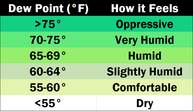
Weather experts say the dew point is a better indicator of how humid it will feel outside than relative humidity.
In June, the average dew point was 69.3 degrees. Dew points in the mid-70s gave us heat index readings in triple digits seven times last month.
Justin Gibbs, a senior meteorologist with the National Weather Service, says the high dew points are typical of a hot summer.
click to download audioThe average temperature in June was 76.2 degrees, about one degree warmer than last year and the highest since 2018. However, the number of 90-degree days was two fewer than last year.
Gibbs says higher temperature readings usually mean a higher dew point.
click to download audioGibbs says Dew points over 70 degrees usually make hot weather feel more oppressive, while dew points in the 50s usually make the air feel dry and comfortable.
In June, there were 16 days with a dew point above 70 degrees according to the Kentucky Mesonet, with a high reading of 75 on June 25 when the temperature hit 92 degrees and produced a heat index reading of 105 degrees.
The lowest dew point reading of June was 60 degrees on June 10, when we experienced our coolest low temperature of the month at 57 degrees.