An unstable weather pattern is setting up across parts of the lower Ohio Valley, and officials with the National Weather Service are warning of possible severe storms Thursday, and a more dangerous outbreak Friday.
Forecasters at the NWS Paducah office have placed portions of southeast Missouri, southern Illinois, southwest Indiana, and western Kentucky under a Slight Risk (Level 2 of 5) for severe weather Thursday. While storm development remains uncertain, any storms that do form could bring baseball-sized hail, damaging winds over 60 mph, and isolated tornadoes.
The highest risk Thursday is expected in the early to mid-afternoon, with a possible second round developing late evening into the overnight hours.
Confidence remains low to medium for both the timing and development of Thursday’s storms, but meteorologists are asking the public not to dismiss the threat.
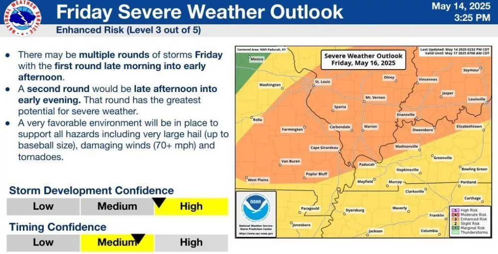
By Friday, the threat intensifies, especially around the Ohio River — where the National Weather Service has upgraded that region to an Enhanced Risk (Level 3 of 5), and a Slight Risk (Level 2 of 5) for most of the News Edge listening area.
Multiple rounds of severe weather are possible, with the most dangerous window arriving late Friday afternoon into the early evening. A very favorable environment will be in place to support all hazards including very large hail, damaging winds over 70 mph, and tornadoes.
Forecasters are emphasizing that the potential for widespread damaging winds and tornadoes is greater Friday, with both storm timing and development confidence rated medium to high.
Conditions are expected to be hot and humid heading into the weekend, further fueling instability in the atmosphere. The weekend forecast also remains unsettled.