The National Weather Service has upgraded the forecast for Monday and Tuesday to an Extreme Heat Warning, with a Heat Advisory in place until noon Monday, and an Extreme Heat Watch for Tuesday night and Wednesday.
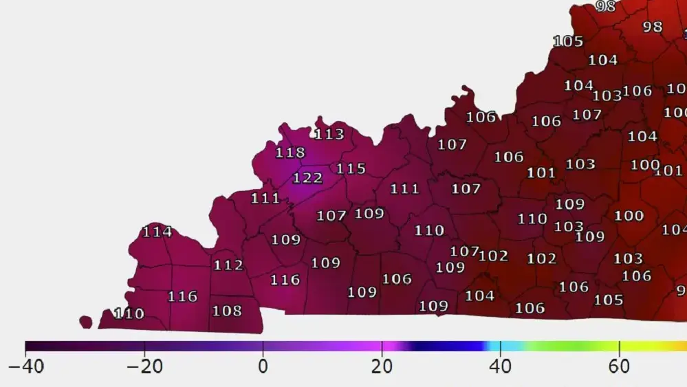
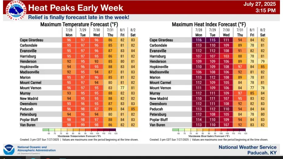
The National Weather Service says extreme heat and humidity will reach a climax Monday and Tuesday, with heat indices of 110 to 115 expected. With daytime high temperatures expected to reach the mid-90s both days the National Weather Service upgraded to the Extreme Heat Warning Sunday.
The extended duration of high temperatures and humidity increases the risk of heat-related illnesses, such as heat exhaustion and heat stroke. The National Weather Service warns that heat illness remains possible to likely, especially for young children, the elderly, and individuals with chronic medical conditions.
Key safety recommendations include:
Avoiding outdoor activities during peak afternoon hours
Drinking plenty of water to stay hydrated
Wearing light-colored, breathable clothing and sun protection
Taking frequent breaks if you must be outdoors
Checking regularly on elderly family members, neighbors, and pets
Spending time in air-conditioned spaces
Never leaving children or pets inside parked vehicles
Residents are urged to “Beat the Heat” by staying informed, limiting sun exposure, and bringing pets indoors. The message is clear: this heat wave can be dangerous—even deadly—without proper precautions.
Isolated to scattered thunderstorms are possibly in the region Monday, with better chances of rain to return to the forecast on Wednesday night and Thursday. Lightning, brief torrential rainfall, and gusty winds will be the primary concerns.
As the heat builds, the National Weather Service encourages the public to stay alert for any additional warnings or advisories. Visit weather.gov/pah for the latest information and heat safety resources from the National Weather Service in Paducah.