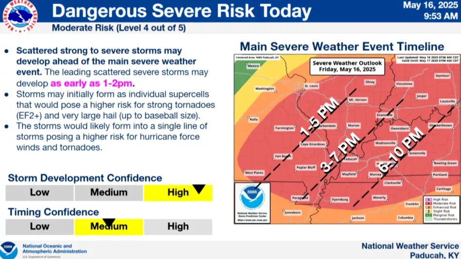
Following an 11 AM conference call Friday, officials with the Paducah National Weather Service office remain keyed in on this afternoon’s and evening’s Moderate Risk (Level 4 out of 5) for severe weather across the Quad-State area.
The potential for dangerous storms, large baseball-sized hail and strong tornadoes — EF-2 or higher — is still high.
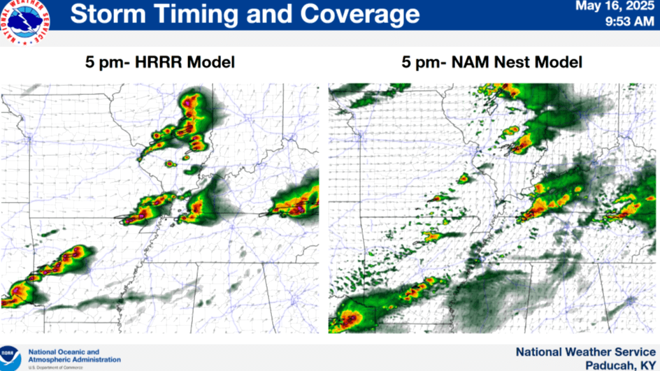
Forecaster Kate Shawkey said storms could begin developing as early as 1-3 PM in the Missouri bootheel, before moving into west Kentucky and the News Edge listening area. Depending on development, she noted storms could fire along the Ohio River between 3-7 PM, and would be passing through Graves County, Calloway County and Trigg County between 6-10 PM — with two rounds of storms possible between the afternoon and evening hours.
This morning’s early storms, she added, did nothing to lower the area’s instability, as clear skies have already moved in across the Quad State — which will warm the region to above 80 degrees. All of western Kentucky, she said, has a 30-45% probability for severe hail.
She said several of these storms are expected to merge into a fast-moving line, increasing the risk for damaging hurricane-force winds and embedded tornadoes — with the potential for supercells ahead of the line.
And it’s these supercells, these taller clouds, that have the biggest hail threat.
For west Kentucky, the main severe weather window stretches from 2 to 9 PM, and possibly into midnight, peaking during the late afternoon and early evening.
Shawkey also noted that the STP, or Significant Tornado Parameter, along the Kentucky/Tennessee state line shifts between a 4 and a 7 throughout the afternoon and evening — and that means a “pretty high” concern for tornadic possibility.
Furthermore, Shawkey said the region does get precipitously close to “derecho” territory. A derecho is a widespread, long-lived, straight-line wind storm that is associated with a fast-moving group of severe thunderstorms known as a mesoscale convective system. They cause hurricane-force winds, heavy rains and flash floods, and in many cases the convection-induced winds take on a bow echo, or backward “C,” and form of squall line.
Residents are urged to complete any outdoor errands or travel early in the day and remain indoors during storm periods.